

Our Journey to Ouarzazate

Driving through the High Atlas mountains
Dear Fellow travellers,
We are travelling in a mini-van, and our driver's name is Hallid. He is from Fes (Fez), and is taking very good care of us.
From Marrakech we drove to Ouarzazate, from where we are now writing to you. To get here we had to cross the High Atlas mountains. This is the highest mountain range in North Africa. The Atlas mountains are 800 Kilometers long from north to south, and in some places 100 wide. One kilometer (km) is a little bit less than a mile. Crossing the mountains we drove over the Tizin 'n' Tichka Pass, heading southeast to the Draa Valley and the town of Ouarzazate.
The whole journey was 204 kilometers (128 miles).
(Another lesson on the metric system - see if you can find the comparison, and tell us how many miles is 800 kilometers?)
This is where the Berber people live and prosper. The guidebook says that the "villages seem to grow out of the hollows in the hillsides, flat-roofed, low and angular, the same color as the earth." The views are spectacular, and the road is so winding - Lucy said it looked like roads from, the roadrunner cartoons! Along the way we passes little tourist stalls where people are selling fossils, minerals, and geodes that they go way up into the mountains to find. We stopped and bought some walnuts from a small group of young boys, from 6-12 yars old. Hallid our driver is Berber and very familiar with the area, and we were able to speak to the boys a little bit. We told them we are teachers and that we teach children close to their ages.
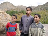 Berber children we met along our drive through the Tizi 'n' Tichka Pass
We stopped at the Kasbah of Ait Benhaddou. A kasbah is a fortified house with either a single tower or4 towers, one at each corner of the wall. Powerful families built these at different times in Moroccan history to control the trade in the area. From their position on the hillside and from the towers they could see a caravan coming from many kilometers away, and stop them, tax them, or whatever they wanted; This is important in Silk Road trade. To get to the Kasbah, we had to cross a small river by stepping on stones. If it was December, we couldn't cross because the river would be full of water - but now is the dry season and the river is dried up. We walked by a camel resting all alone. The man sitting outside probably lives there.

 We had a restful night in the hotel Salaam (Peace hotel), which is modern but has a lot of traditional architectural details and geometrical shapes.


Ouarzazate was built in 1928 as a "garrison post on the threshhold of the Sahara" (in the words of our guidebook). It is now home to a lot of movie studios - we learned that many movies have been made here, including Lawrence of Arabia; Jewel of the Nile; Kundun; and lots of others.
===================================================================
Now we are off back through the High Atlas mountains to the Draa Valley, on to the oasis town of Zagora. The Draa is Morocco's longest river. Tonight we will spend the night in a tent in the Sahara desert, and in the morning we will wake up early and ride our camels out into the dunes to watch the sunrise! After that we're on to Erfoud, so it will be a couple of days before we can get on the internet and write again.
Farewell for now! Au revoir!
Love, Alicia and Lucy
posted by Alicia Carroll and Lucy Montgomery | 5:55 AM
![]()
0 Comments:
Post a Comment
<< Home